

It bothers me to have spent the money on a nice RV and then just watch it sit idly parked in my yard; and this irritation is compounded by the knowledge that in just a short month from now, it will be too cold outside to use it comfortably (which is to say, to use it with all the water systems functioning). So I decided to take this weekend, and a couple of October weekends as well, to put some more miles on the Little Guy.
I wanted to play golf in the western part of the state this fall and was surprised to discover that a lot of other people wanted to travel this way as well; Grafton Notch Campground was the third campground I investigated for this trip as the other two were sold out during this last weekend of September. But I am not disappointed, as it is a small (fifteen sites) but lovely campground just on the outskirts of Grafton Notch State Park, and as such is a prime hiker destination – western Maine is home (along with eastern New Hampshire) to the White Mountain National Forest and there is an abundance of beautiful hikes within an hour of here, including of course Mt. Washington (the highest peak in the northeast). So anybody wishing to spend some time hiking and climbing in the White Mountains could do much worse than to camp here.

This area is accessed via ME-26 from Bethel. On my way through Bethel I spied a young couple, obviously hikers, hitchhiking on the outskirts of town. Upon picking them up I discovered that Michelle and Timmy had been hiking for months on the Appalachian Trail (known locally as “the AT”), starting in late spring in Georgia and then walking all the way here since then. Pressed by the calendar and the knowledge of autumn’s impending snow and cold at elevation, they had decided to skip the section of the trail between the Maine/NH border and hitchhike to Skowhegan, in hopes of then traversing the 100-Mile Wilderness and finally completing the AT on Mt. Katahdin.
I decided I had the time and gas to take them as far as Rumford, for which they were most grateful as it had been raining hard for over an hour when I picked them up. Michelle, it turns out, is a pre-K teacher at a private school in New Hampshire; Timmy is a river-rafting guide in the summer and a ski instructor in the winter, shuttling between the Ocoee River in Tennessee and the big peaks of Colorado over the course of the year. They had met on the trail and apparently were soon to part, as they had differing schedules to keep and obligations to meet. But they were a delightful “couple” and I was happy to ease their travails somewhat by driving them along Route 2 as far as the McDonalds in Rumford. I hope they finish their goal before autumn overtakes them.
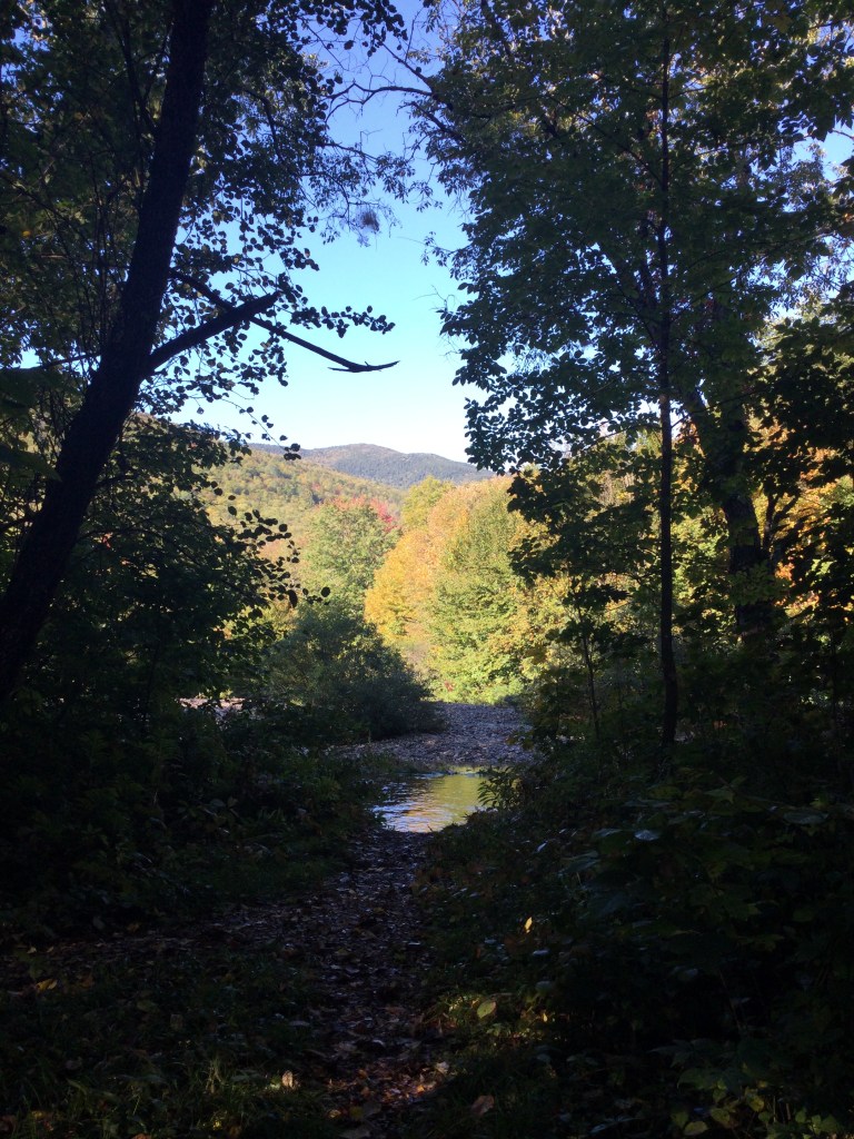
Grafton Notch Campground is not a destination for those with kids to entertain. While there is a lovely open lawn near the scrupulously clean bathhouse, there are no swing sets or playgrounds for kids; nor is there a beach or pool for swimming. The lawn holds a nice picnic area, a cornhole set and a horseshoe pit and would be a delightful space in which adults could relax. The campground is decorated with tasteful flowerboxes and plantings, and several sites have short trails leading down to the Bear River, a lively stream with several musical riffles to serenade one to sleep. The campsites are mostly level, although for RVs the access is sometimes tight, requiring careful maneuvering between sentinel trees guarding the entrances; each has a nice picnic table and a firepit. In short, this is a lovely small campground with mostly private sites in a heavily wooded setting, ideal for adult hikers or anyone planning excursions to nearby Bethel or North Conway, NH.


Special mention should be made of the lovely scenic highway ME-113 very near here and well worth a visit — check an earlier blog post for details and photos – but if you are in this area between May and October it would be a shame not to drive this very interesting and scenic road.
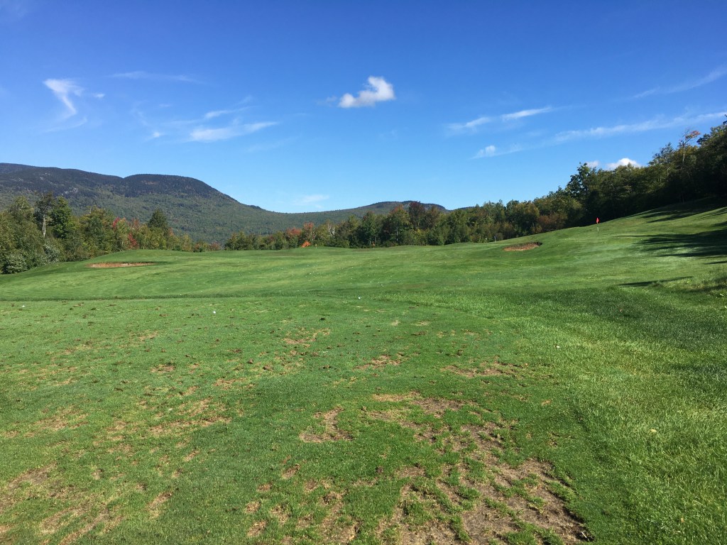
I arrived on Friday afternoon and began the day on Saturday hoping to find a golf driving range upon which to practice the techniques learned in my latest golf lesson. I therefore drove back to Bethel and inquired of their driving range, only to learn that it was underwater after yesterday’s heavy rain! So I called nearby Sunday River Golf and discovered that their range was open, so there I went.
Sunday River is my favorite of all the courses I have played in Maine. The scenery is spectacular, with mountain views on every hole, and the fairways are bowl-shaped, which means that any reasonably decent shot will be funneled into play rather than bounding into the woods. Even the driving range is lovely!
Having reinforced my golf technique, I next determined that I would like to pay another visit to Table Rock, a spectacular promontory which juts out over ME-26 from the flanks of Baldpate Mountain, and which Robin and I had visited perhaps thirty years ago. The route to the Table Rock access trail – the AT – takes one along ME-26 first past lovely Step Falls. This is just north – less than half a mile – of the Grafton Notch Campground and is located just beyond a big field with a large white farmhouse at the end of it. The sign marking the parking lot is a very small white and blue sign which could easily be missed.
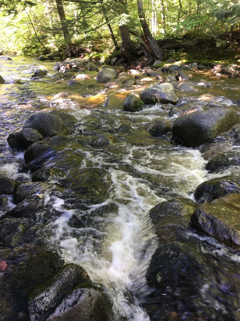


Just north of Step Falls is Screw Auger Falls, a particularly deep chasm spiraling down along ME-26. While the geography here is perhaps more interesting than Step Falls, the scenery is somewhat less photogenic owing to the depth of the gorge and the way the trees crowd in upon it. Here is a photo of Robin there, taken some years ago.

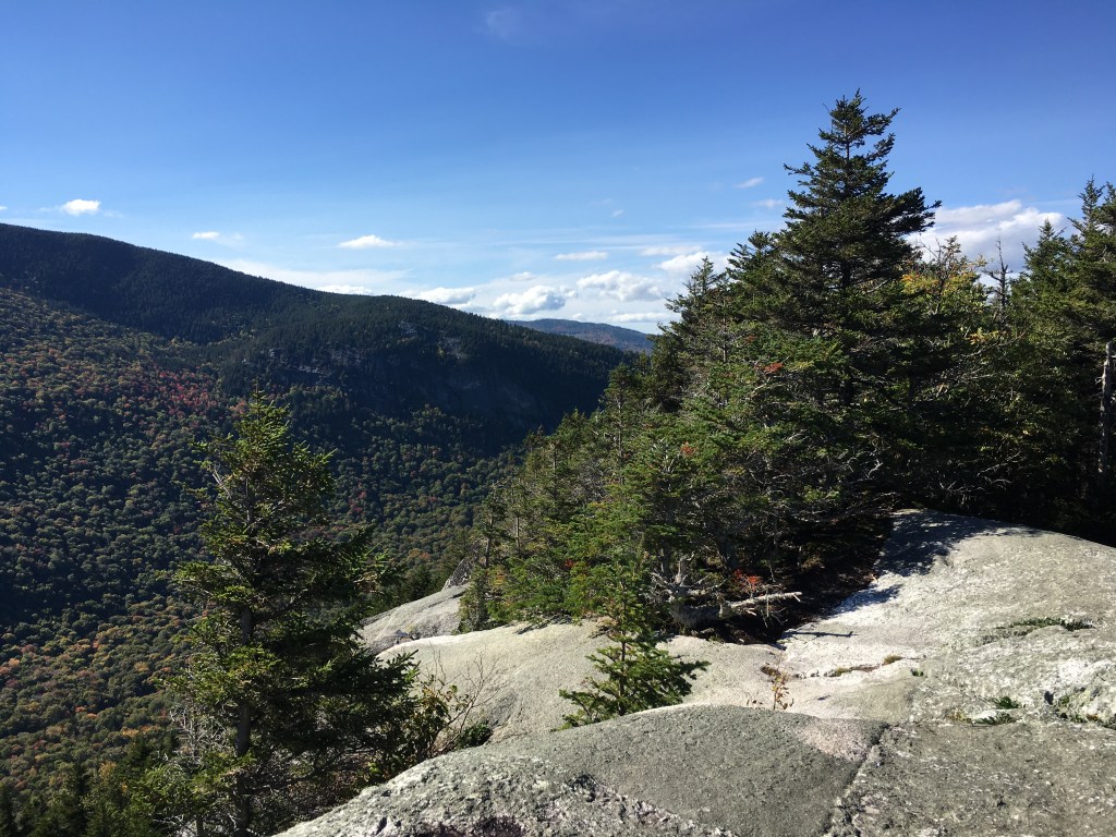
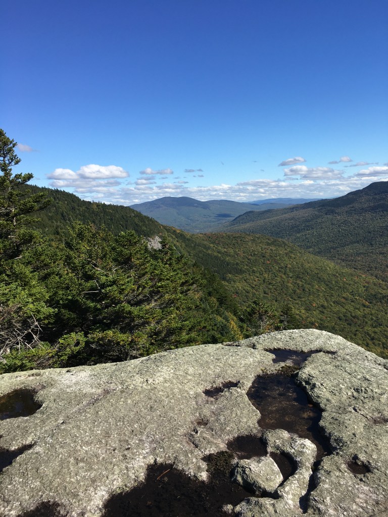
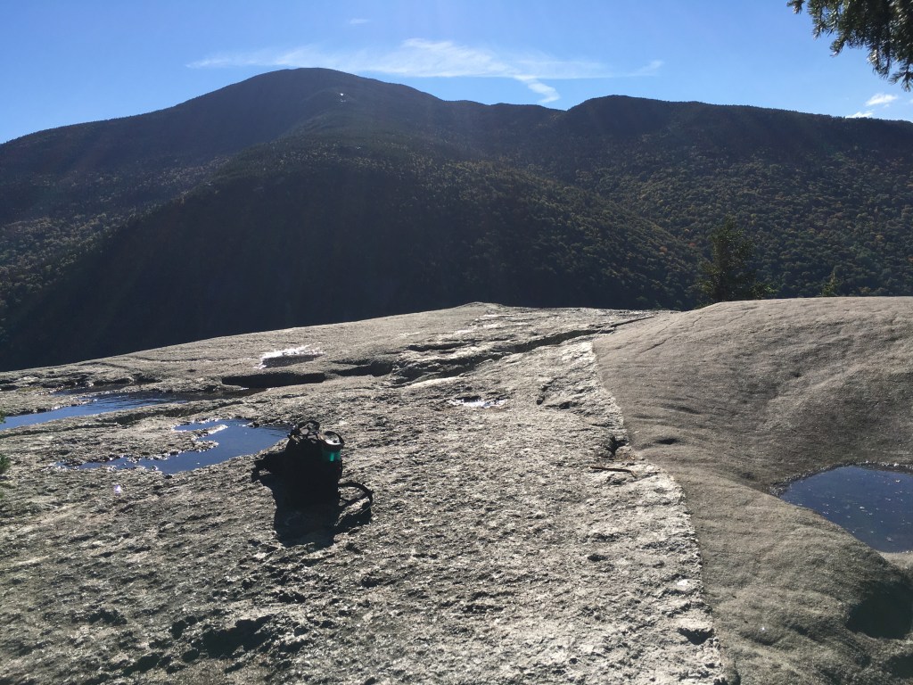
Screw Auger Falls is followed by Mother Walker falls and Moose Cave, both worth a visit, although to my memory less captivating than the others, so I did not stop there this trip, instead continuing north to the hiking trail parking lot which is well marked. The trail to Table Rock, my hiking destination for the day, is across the road from the parking lot. Table Rock itself is a 40-foot square granite promontory, precariously perched on the side of Baldpate Mountain, precipitously overhanging ME-26 and offering spectacular views. Now consider this photo:

As you can see, Table Rock can be approached either from the AT (the large green dashed line running left-to-right in the map photo above; the red line is ME-26) or via a smaller trail which runs first east and then north. This is, in fact, the trail I took – and found it to be at the very limit of my ability. This trail is overall quite steep, and there were two or three spots where I seriously considered turning back, because the trail traverses piles of large boulders which required every millimeter of flexibility I had to step up on, and every ounce of leg strength I possessed in order to lift my fat *ss up and over. This trail is marked in orange blazes and is the shortest approach to Table Rock, but is by far the steepest — to the point where it occasionally is necessary to drive rungs into the rocks so that hikers can continue their ascent. As previously noted, Robin and I had climbed to Table Rock maybe thirty years ago but I did not remember it being so strenuous and difficult. I suppose thirty years can do that to a guy……

Anyway, here is where it pays to be able to read a topographical map. As you can see from the map photo above, the AT (and the small connecting trail from there to Table Rock) ascends much more gradually than the eastward approach. Noticing this, I determined NOT to descend via the same eastward trail, but instead to assay the longer route back, which utilizes the AT. I discovered this route to be MUCH easier – in fact, I could walk the entire route down, whereas for most of the other route I was clambering up rocks on all fours. My route thus ended up being a counterclockwise circle. I believe the eastward approach to be too dangerous to descend, and if you attempt Table Rock, I strongly recommend going up AND back by way of the AT. But whatever you do, don’t try to descend over the orange-blazed eastward route; I am confident that, had I done so, injury would have been almost certain, and it is doubtful (given the added time it would have taken to traverse down the boulder fields) that I would have made the descent before nightfall.


And if you are interested in learning to read a topo map and use a compass (something I think is a required life skill for everyone!), I can do no better than to recommend to you the classic “Be Expert With Map and Compass” by Bjorn Kjellstrom; master the concepts in this book and there is no wilderness anywhere that you cannot travel with confidence!
I spent a delightful evening at the next campsite with Mike and Shawna, owners of a T@B teardrop camper, who regaled me with stories of their canoe trips. Retired canoe guides, they have taken trips down all the rivers of Maine along with many others in the American Southwest and the Canadian Yukon. Veteran RV campers as well, they had a number of good tips about RV batteries, camp lights, and other items of interest to an RV geek like me. Delightful folks — I hope to cross paths with them again sometime down the road!
So — ME-26 and Grafton Notch State Park – a fabulous destination for waterfalls and hiking! Spend some time at the highly recommended Grafton Notch Campground and check it out!

Sounds like a challenge a d some fun. Hope to see you soon. Lois
LikeLike
John, I loved reading your very interesting, informative, and detailed blog! Which will entice me to read your others! I have hiked many mountains in Maine some with the girls years ago and more recently a few years ago with the hiking group that the Farmington recreation department sponsored for us older folks. Which sadly is no longer being offered. Have a wonderful time hiking our beautiful state and neighboring state!
Wilylabrie@aol.com
LikeLike